Estimated read time: 5-6 minutes
- The National Weather Service issued multiple warnings and advisories as more snow heads to Utah.
- The Wasatch Mountains may receive up to 2 feet of snow or more by Wednesday.
- Drivers are advised to use caution as snow is forecast in the valleys during the Tuesday morning commute.
SALT LAKE CITY — Last week's stormy pattern proved to be fruitful for Utah's snowpack, and more snow is forecast to start this week.
The National Weather Service issued winter storm warnings for a portion of the Wasatch Mountains and parts of the Salt Lake Valley, and a series of winter weather advisories ahead of another system arriving in Utah. By Wednesday morning, some mountain locations could receive up to another 2 feet of snow, while many valley communities and bench areas could receive several inches.
Utah Department of Transportation officials are urging drivers along the Wasatch Front to delay Tuesday morning commutes as a result.
Storm timing
Last week's storm pattern dumped nearly 4 feet of snow at Alta, Brighton and Snowbird resorts, while other parts of the Cottonwood Canyons received at least 3 feet of snow. Brian Head also ended up with over 2 feet, as southern Utah received some crucial late-season snow.
KSL meteorologist Matt Johnson explained that another low-pressure system was off the Pacific Northwest coast early Monday, but it will be quickly arriving in Utah behind a "potent" cold front.
Winds have picked up across Utah ahead of the cold front's arrival. The weather service issued a handful of wind advisories across western Utah that will remain in place through Monday night. Wind gusts of 55-60 mph are possible throughout the day.
Meanwhile, a mix of valley rain and mountain snow is forecast to arrive in northwest Utah by Monday evening before expanding to other parts of the state. Johnson said rain will switch over to snow as the cold front pushes through in the overnight hours, leaving valley snow that is expected to linger during the Tuesday morning commute.
The system will start to clear out throughout the day, but weather models indicate some lingering snow showers are likely in the Wasatch Mountains Tuesday night and possibly into early Wednesday.
"By Wednesday afternoon, we are completely dry," Johnson said.
Storm accumulations
Wasatch Mountain locations south of I-80, including Alta and Brighton, are included in the winter storm warning. It states that 14-24 inches of snow is possible between Monday night and Wednesday morning, while wind gusts up to 45 mph could also create issues. Some models indicate higher totals are possible.
TONIGHT - TUESDAY: Forecast snow totals.
— Matthew Johnson (@KSL_Matt) March 17, 2025
Alta 15-30"
Snowbird 15-30"
Brighton 12-24"
Solitude 12-24"
Eagle Point 8-16"
Brian Head 8-16"
Snowbasin 7-14"
Powder Mtn 7-14"
Beaver Mtn 6-12"
Park City 6-12"
Deer Valley 6-12"
Cherry Peak 5-10"
Sundance 5-10"
Nordic Valley: 3-8" pic.twitter.com/yvynvqbsuk
The agency elevated Salt Lake Valley into a storm warning, where 2-6 inches of snow is possible along the valley floors and 6-12 inches by its benches. The change was made because models hint at the cold front "somewhat stalling" over the area, along with possible lake-effect snow. It's all happening in the state's most-populated county during the morning commute hours, said Christine Kruse, lead meteorologist with the National Weather Service.
"When you put several inches of snow on our main roads and our side roads during the morning commute, it has an even bigger impact," she said.
The agency's winter weather advisories cover many other mountain and valley locations across Utah. Those advisories state:
- 5-12 inches of snow is possible in the Wasatch Mountains north of I-80, as well as the Western Uinta, Wasatch Plateau/Book Cliffs, central and southern mountain ranges. "Locally higher" amounts up to 15-18 inches are possible across parts of the northern mountains, in the Manti-Skyline area, within the Tushar Range and by Brian Head.
- 4-9 inches of snow is possible in the Wasatch Back, including Heber City, Huntsville and Park City. Lower totals of 2-5 inches are projected for areas below 5,500 feet elevation in the area.
- 2-5 inches of snow is possible in parts of central and southwest Utah, including Beaver, Cedar City, Fillmore, Nephi and Scipio.
- A trace to 4 inches of snow is possible across other Wasatch Front and northern Utah areas. Johnson said lower totals are projected for Utah County because of potential mountain shadowing, while higher totals are possible in the Tooele Valley and by bench areas, especially in Davis County.
Meteorologists advise that additional snow could fall in southern Davis and northern Salt Lake counties on Wednesday from more lake-effect moisture.
Storm impacts
The weather service advises drivers to "slow down and use caution while traveling." Kruse said people in Salt Lake, Davis and eastern Tooele counties should consider delaying their commutes and checking UDOT road condition reports before heading out.
"It is a good idea to consider postponing your commute, especially if you're commuting before 8 a.m. (Tuesday)," she said.
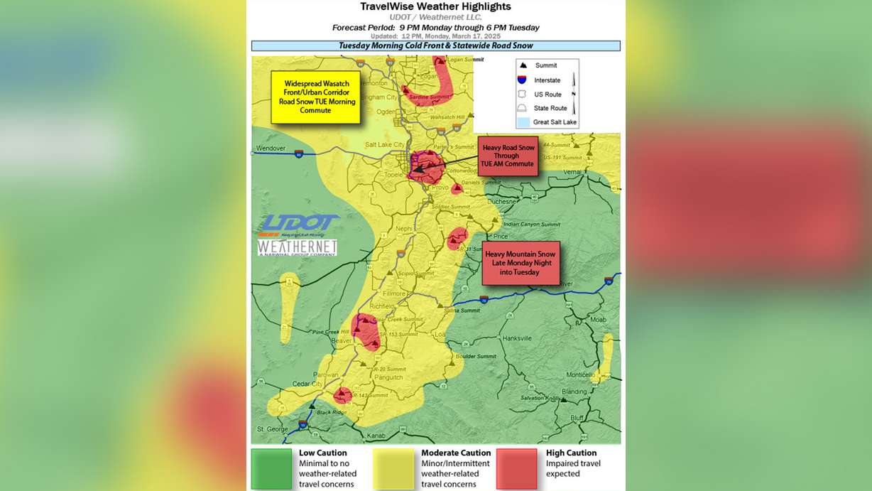
UDOT issued a road weather advisory, urging drivers to use "high caution" while traveling through mountain passes and also the southern portion of Salt Lake Valley Tuesday morning. The agency also urged drivers across the Wasatch Front to delay travel until after 9 a.m. or take transit "to give our crews time to clear the roads."
We are asking you to delay travel tomorrow (3/18) morning if possible. We're expecting more snow, and the morning commute could be a bit tricky.
— Utah DOT (@UtahDOT) March 17, 2025
Please share to spread the word. 🤝 pic.twitter.com/Ed0CzhJC73
As for people recreating in the snow, Utah Avalance Center forecasters already list many of the state's mountains as having "considerable" avalanche danger.
Heavier snow could impact trees as they start to bud early, but Kruse says the bigger impact is often when tree branches are "fully leafed out" like what happens early or late-season snowstorms.
The additional snow should also help Utah's snowpack, which has already made major gains this month. Utah's statewide snowpack is now back to 100% of its median average for this point in the year, and 84% of its seasonal average with 17 days left before its median peak, per Natural Resources Conservation Service data updated on Monday.
The Great Salt Lake basin is now 110% of its median average for mid-March and close to its seasonal normal with a little over two weeks left before its normal peak, showcasing how strong of a season the northern half of the state has had. While still 58% of its median average, the latest storm elevated the Southwestern Utah basin's running total out of record-low status again, as the state's driest region has received much-needed moisture.
Utah's active pattern isn't over yet, either. Johnson said another storm or two could impact northern Utah this week. Another round of rain and snow is forecast to arrive on Thursday while another storm could impact the region over the weekend.
Full seven-day forecasts for areas across Utah can be found online, at the KSL Weather Center.