Estimated read time: 4-5 minutes
- Utah's winter has varied by region, with parts of southern Utah experiencing record dryness.
- Spring forecasts suggest warmer, drier conditions overall, potentially impacting snowpack crucial for water supply.
- Officials emphasize water conservation as Utah braces for below-average spring runoff across most basins.
SALT LAKE CITY — There's still a week left in Utah's meteorological winter, but it's safe to say it's been a different winter depending on where you live in Utah.
The state entered February on pace for its 10th driest and 21st warmest winter since statewide records were established in 1895, but counties ranged from having their driest December-January periods on record in southern Utah, to totals less dire circumstances in northern Utah, per National Centers for Environmental Information data.
Conditions improved in February, but the divide between regions still exists toward the end of the season. New long-range models indicate these trends could continue to start meteorological spring, but the season may also be warmer and drier than normal. That could have implications as the state's vital snowpack collection season comes to an end.
"The spring can make or break our snowpack," said KSL meteorologist Matt Johnson. "It puts the icing on top, or no icing, and the snowmelt starts early."
Ending a slow winter strong
Utah's averages through the first two months of meteorological winter show exactly how winter storms followed northern Utah more than other regions in the state. Per federal data, Beaver, Iron and Washington counties were still on pace for their driest winters on record after Jan. 31, while Box Elder County was the closest to its normal after January. It ended last month on pace for its 56th driest winter.
Recent storms have been productive for all parts of the state, but those same trends still exist. Utah's statewide snowpack is at 93% of its median peak for this point in the season, per Natural Resources Conservation Service data updated on Friday. It had fallen to 76% at the start of this month.
It's boosted by Utah's northern half, which is inching closer to a third-straight above-normal snowpack.
The Bear River basin, for instance, is now at 110% of its median average for this point of the year. It's also about 76% of its median seasonal average with over 40 days left until its normal peak. Along with other sites, it's part of the Great Salt Lake basin, which has already received 75% of its season average.
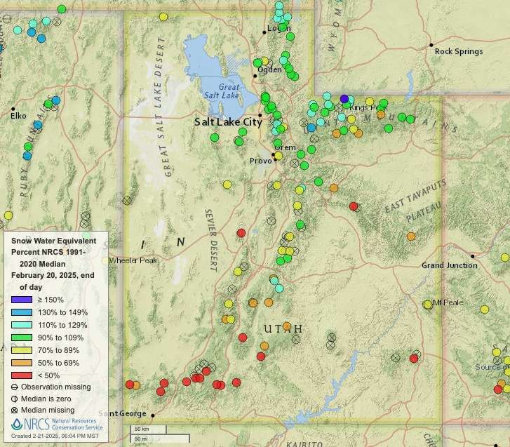
Central and southern Utah basins have also improved but continue to lag behind seasonal normals. Most of central Utah's basins are running between 50% and 85% of their median averages for this point in the year, while Escalante and southwestern Utah basin totals are below 40%. Southwestern Utah's total, which is nearing record-low levels again, is only about a quarter of its seasonal median average with 25 days left in its normal season.
What's in store for spring?
Utah's statewide snowpack collection was at about two-thirds of its seasonal median average, as of Friday, with seven weeks left before the snowmelt process typically begins. Johnson explained that March is usually one of the state's wettest months because a "nice convergence" between the polar jetstream and tropical moisture often forms about this time of the year, producing water-rich mountain snow.
The National Weather Service Climate Prediction Center projects that the La Niña pattern behind this year's winter trends could continue in March, listing most of southern Utah as having a 33% to 40% probability of below-normal precipitation, while the rest of Utah is listed as having "equal chances," meaning there's no clear precipitation signal.
"This means that we could get a nice fetch of moisture at least for this March outlook," Johnson said.
But federal forecasters say there's a 66% chance that La Niña will end this spring. It projects that it will lead to changes that could mean a 33% to 60% probability of below-average precipitation across March, April and May combined. The Four Corners region, including southeast Utah, has the highest odds for dry conditions, while northern Utah has the lowest of those odds.
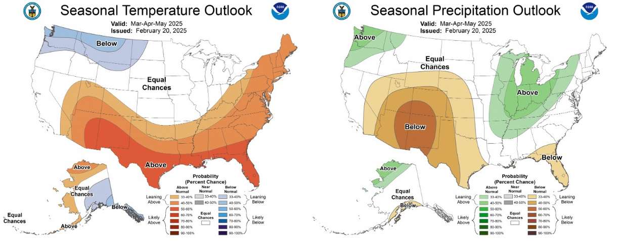
There are still positive signs in the outlook. Odds favor above-normal precipitation, and equal chances are lined up through the Pacific Coast, which could mean storms will pass through the region — possibly breaking into Utah. Johnson says the spring jetstream patterns are typically open to wider swings in weather that could push storms into the state.
This outlook, he adds, suggests that the rest of spring could produce waves of storms between warm, dry periods like those produced during winter.
Bracing for the worst
The snowpack collection and spring runoff process accounts for about 95% of the state's water supply. The snowmelt process is delicate and requires the right conditions to be effective, which is why spring is so vital for the state.
Spring storms could help northern Utah basins get closer to seasonal normals by the end of the snowpack collection season. Yet, basins in central and southern Utah still have a long way to go before they return to normal.
Candice Hasenyager, director of the Division of Water Resources, said on Wednesday that the state is now bracing for "below-average streamflows this spring runoff" across most basins.
The bright side is Utah's reservoir system remains about 80% full ahead of the snowmelt. Still, Hasenyager added the conditions are a reminder of why water conservation measures are important.
"With low precipitation and an underperforming snowpack, we must continue using water wisely to maintain our quality of life," she said.