


Estimated read time: 5-6 minutes
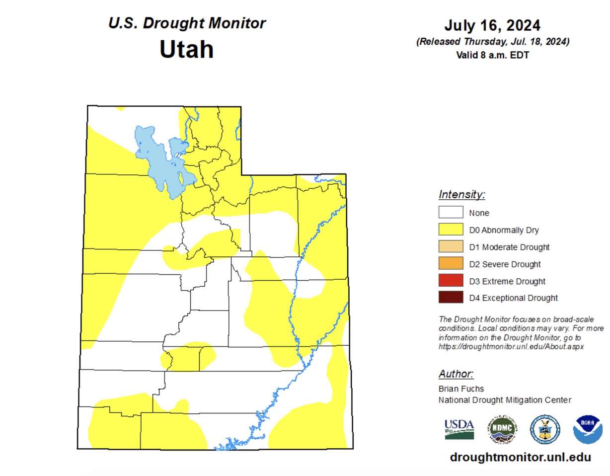
SALT LAKE CITY — Utah remains drought-free after back-to-back productive winters, but "abnormally dry" conditions are quickly returning across most of the state.
About 53% of Utah is listed as "abnormally dry," up from 33% last week and nearly 25% at the end of June, according to the U.S. Drought Monitor. The category — not quite drought but also below-normal soil moisture — has now spread to most of the Wasatch Front, West Desert areas and northern Utah, as well as sections of central Utah.
The growth of these conditions comes as hotter and drier weather has emerged after a second straight above-average snowpack season.
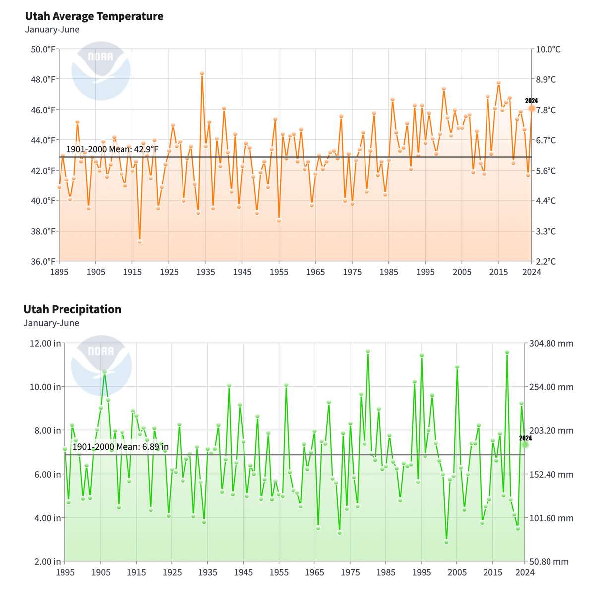
Utah's 2024 climate data so far
Utah received, on average, 7.35 inches of precipitation during the first half of this year, which is 1.91 inches below the collection from the first six months of 2023 but 0.46 inches above both the 20th-century average and 30-year normal, according to National Centers for Environmental Information data published on July 9.
But a little over 70% of the state precipitation this calendar year fell between Jan. 1 and March 31 from storms that helped boost the state's struggling snowpack to a second straight above-normal collection. April, May and June weren't exceptionally dry, but all three months fell below averages and normals.
At the same time, this year remains on pace to be one of the state's warmest on record. With an average temperature of 46.1 degrees Fahrenheit, Utah tied 1940 and 2014 for its 10th warmest first half on record. That's a big change from the first half of last year, which — at 41.7 degrees — was the 27th coolest on record.
So what happened? Utah benefited once again from atmospheric rivers — a series of low-pressure systems with heavy moisture — that ended up in the state, particularly in the first quarter of the year. Nearly one-third of Utah's final statewide snowpack total came in February alone, per Natural Resources Conservation Service data.
That predominant pattern shifted in April. KSL meteorologist Matt Johnson explained that's when more high-pressure systems moved in, leading to hotter temperatures and fewer storms. Many of the summer systems, so far, have formed off the Pacific Ocean, which makes it difficult for monsoonal rain to reach Utah.
"We've definitely seen our precipitation drop a cliff," Johnson said.
These trends have lingered into at least the first few weeks of the second half of 2024. Salt Lake City, for example, is on pace for its fourth-hottest July on record, while it hasn't received measurable rain since June 21. St. George only had its 78-day stretch without measurable rain snapped this week.
Outlook and impacts
There's both good and bad news putting all of the data and projections together. The good news is Utah's reservoir system peaked at about 93% of capacity after the snowpack runoff, its highest point since 2011. It remains 88% full, about 16 percentage points above the July median capacity.
Gov. Spencer Cox said he thinks this reflects a change in water consumption habits since Utah's last drought, which was considered one of its worst on records. He said he thought that Utah's water levels would have dropped to 80% or less based on pre-drought habits; however, he thinks Utahns have found ways to use less water while the state is also doing better at offering programs to be more efficient with what it has.
"Last year was the first year where we had historic snowfall, and people did not increase their water use per capita. It was really remarkable," he said during his monthly press briefing on Friday. "I believe there has been a paradigm shift in our state where people are really starting to get it."
The bad news is all the moisture led to better vegetation growth over the past two springs, which requires constant precipitation to avoid drying out. The "abnormally dry" portions of Utah reflect where there's drying soil moisture and emerging precipitation deficits.
There's also some crossover to where the state's strongest fire danger spots are. The Great Basin Coordination Center lists the Wasatch Front, West Desert and southwest Utah regions as having above-normal fire conditions right now, which may linger through the rest of the summer.
Salt Lake City firefighters referenced this after the Sandhurst Fire broke out near Ensign Peak on Saturday, scorching about 200 acres by Saturday night.
"Because we had such a wet winter, it leads to high fuel content in vegetation. That moisture content can be down really fast, especially with this heat," said Salt Lake City Fire spokesman Bob Silverthorne.
Trends could change depending on how the monsoon season plays out. Some scattered storms returned to Utah this week, and that may not change for southern Utah for most of next week. National Weather Service Climate Prediction Center long-range models appear to favor storms across Utah going into the end of the month.
But the center projects hot and dry conditions will return by early August. Both its August and three-month outlooks offer Utah few favors, listing the state with higher probabilities of above-normal temperatures and below-average precipitation.
Johnson says this doesn't mean Utah won't get any storms during that time or that the state's fate is sealed, but models seem to favor conditions that typically lead to less moisture in Utah. It means the state may continue to dry during the second half of this year.
"We'll probably still get the (monsoon) setup in one way, shape or form but it's looking like it won't produce the way we normally expect it," he said.


