Estimated read time: 5-6 minutes
SALT LAKE CITY — Utah transportation officials have floated around a proposed fourth light-rail service option for some time, but what it could look like is becoming a little more clear.
Utah Transit Authority officials are asking for more public input now that they have decided on the final four options for what the proposed "Orange Line" would look like as the agency works to finalize its TechLink TRAX Study. The line would connect the University of Utah with Salt Lake City International Airport via downtown Salt Lake City with some other major changes to service.
New service to the university's Research Park, located southeast of where the line currently jets out toward its Medical Center terminus, is included in all four options. The proposed alternatives call for different ways the new line would look in other parts of Salt Lake City — and create significant changes to the existing Blue, Green and Red lines.
Alternative 1
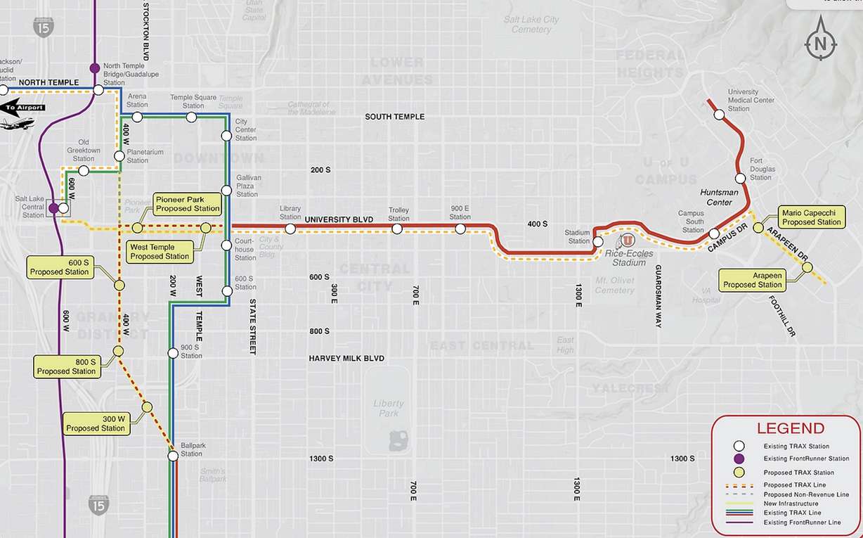
The first option calls for two new stations that would be located south of South Campus Drive where the line connects with Mario Capecchi Drive. One station would be located on Mario Capecchi Drive, and the line's eastern terminus would be on Arapeen Drive in the Research Park area.
The line would share the same route as the Red Line along University Boulevard (400 South) before going in different directions. The Orange Line would continue onto a new route along 400 South before connecting with Salt Lake Central Station (340 S. 600 West), utilizing the existing Blue Line from Salt Lake to Planetarium stations before using the current Green Line to connect with Salt Lake City International Airport. New stations along the 400 South route would be placed at West Temple and Pioneer Park.

This would also change the three existing routes. The Blue Line would run from the airport to Draper, and the Green Line would run from Salt Lake Central to West Valley City.
The Red Line would have the most drastic changes, joining the Orange Line on the new 400 South route instead of turning on Main Street as it currently does. It would stop at the West Temple and Pioneer Park stations before turning south at 400 West and cutting through the emerging Granary District before reconnecting with the existing line at the Ballpark Station on 1300 South. There would also be three other new stations along this new route.
The three other options have different variations of these changes.
Alternative 2
The Red Line tracks would be elevated along 400 West from 400 South to 700 South, with an elevated station at 600 South, under this scenario. All other proposals from Alternative 1 would be included in this plan.

Alternative 3
In this scenario, the Orange Line would turn north at 400 West instead of 600 West. The line would bypass the Central Station and instead reconnect with the existing line at Planetarium Station. All other proposals from Alternative 1 would be included in this plan, and there would be no elevated line.

Alternative 4
This option wouldn't change much from Alternative 1 except that it would move where the Red and Orange lines cross Rice-Eccles Stadium. The current Red Line runs along 500 South and South Campus Drive with a connection at University Street, where Stadium Station is located.
In this scenario, the line would continue along 500 South past the stadium before reconnecting with the existing South Campus Drive after turning north near Guardsman Way. The Stadium Station would be moved to an area located southeast of the stadium instead of directly west of its parking lot.

What happens next?
The massive overhaul is one of the many projects outlined in the "UTA Moves 2050" plan that the agency adopted earlier this month.
Online public comments are currently being collected on the four alternatives. UTA is expected to pick a preferred option before issuing a final report beginning the initial steps in the National Environmental Policy Act process in the coming months.
The project's potential cost and timeline are unclear, largely because the agency is considering different options.
Carlton Christensen, chairman of the UTA board of trustees, said in December that "early estimates" listed the project cost at about $225 million, but he expects that it would cost more than that.
However, the agency is hopeful that Utah's 2034 Olympic bid could help speed up the process and cover a chunk of the expected costs. That's because UTA received federal funds that helped it create TRAX in time for the 2002 Winter Olympics.
"It sometimes speeds up the funding and the participation in the project," Christensen said at the time.
The Orange Line would be UTA's first new line since the agency launched in 1999, though it has gone through plenty of expansions since then.
More stations were added at the University of Utah in the early 2000s. The Red Line was also extended out to Midvale, West Jordan and South Jordan in 2011, and the Blue Line was extended from Sandy to Draper in 2013. The Green Line was extended to West Valley City in 2011 and to the west side of Salt Lake City up to the Salt Lake City International Airport in 2013.
The TechLink project isn't the only major TRAX project being considered. There are also talks about extending the Blue Line farther into Draper toward The Point development, as the service continues to expand.


