Estimated read time: 4-5 minutes
This archived news story is available only for your personal, non-commercial use. Information in the story may be outdated or superseded by additional information. Reading or replaying the story in its archived form does not constitute a republication of the story.
SALT LAKE CITY — Robust monsoonal patterns and remnants of two tropical storms ultimately helped make August Utah's 14th wettest in 129 years, turning the state's meteorological summer completely around, according to new federal climate data.
Utah, on average, received 2.02 inches of precipitation in August, per National Centers for Environmental Information data published on Monday. As a result, the Beehive State collected 3.30 inches of precipitation over the summer season, an above-normal figure that is helping reduce the state's drought and wildfire potential.
Utah's summer average temperature ended up at 69.7 degrees, 1.4 degrees above normal, as well. The average temperature of the past three months placed 34th warmest all-time since statewide data was first collected in 1895.
How August changed Utah's summer precipitation
Precipitation-wise, Utah seemed destined for a below-average summer after the first two months of the meteorological season. The state received 1.28 inches throughout June and July, 0.44 inches below the 20th-century normal.
Then came August.
Monica Traphagan, lead meteorologist at the National Weather Service's Salt Lake City office, explains that a traditional monsoonal pattern began to set up at the end of July and beginning of August, where high-pressure systems set up over areas east of Utah, pumping tropical moisture north into the state. This lingered throughout most of the month.
Remnants of Hurricane Hilary and Tropical Storm Herald only tacked onto August moisture.
"We just had the persistent typical monsoonal pattern, which allows abnormally moist air mass to continue to stream into the area, accompanied by instability from passing (tropical systems)," she told KSL.com.
Utah ultimately received nearly twice its 20th-century August normal precipitation, matching 1932 and 1951 for 14th on the all-time August list dating back 129 years. The state's all-time wettest August record remains at 3.01 inches, set in 1909.
Increased moisture also bumped the state's meteorological summer precipitation collection up to 0.36 inches above normal, making it Utah's 44th wettest summer on record. This trend played out across many communities in the state, too.
Salt Lake City, for example, wound up with its fifth-wettest August in 149 years of data collection, receiving 2.75 inches of rain — nearly five times the city's August normal, per weather service data. So despite a dismal June and July, which combined to produce only 0.45 inches of rain, Utah's capital city ended meteorological summer having received 1.18 inches of rain over its 30-year normal.
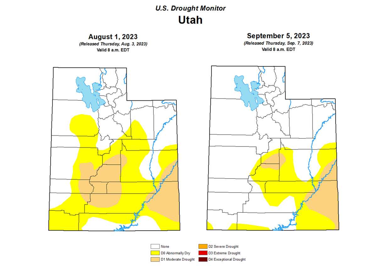
All of this greatly helped drought and fire conditions as the month went on. The U.S. Drought Monitor listed about half of Utah as being at least "abnormally dry," including 16.5% experiencing moderate drought at the start of August. Only about a quarter of the state remains "abnormally dry" and the percentage of the state in moderate drought dropped to 8.3% in its first report after August.

Basil Newmerzhycky, a fire meteorologist for the Great Basin Coordination Center, said in a report last week the "amazing amount" of August precipitation across the West weakened fire potential across the region. Additional storms to begin September only helped conditions improve.
"This is just a slam dunk and really moistens the fuels up," he said, adding that fire potential likely wouldn't increase "anytime in the near future."
The agency currently lists Utah as having normal fire risks for the rest of the year.
Many other Western states enjoyed strong seasonal moisture. Wyoming ended up with its wettest summer on record, while California and Nevada both narrowly missed their respective top 10 lists. The same can't be said of the Southwest, though, as New Mexico and Arizona posted their third and 10th-driest summers on record.
Utah's milder summer heat
Utah's 70.7-degree average in August wound up 1.3 degrees above normal, on par with the rest of the summer. The average summer temperature wound up 1.4 degrees above normal, but 2 degrees below last year's average, largely due to the stormy weather patterns.
(2 of 5) #August avg. temp for the contiguous U.S. was 74.4°F, 2.3°F above avg. — ranking 9th warmest in the 129-year record:https://t.co/DMEkGeGbNf@NOAANCEI#StateOfClimatepic.twitter.com/T3xmaQX4YG
— NOAA (@NOAA) September 11, 2023
It wasn't as close to normal in other parts of the country, especially in the southern parts of the contiguous U.S.
After more heat in August, Louisiana experienced its hottest summer on record, while Florida, Texas and New Mexico's summers narrowly missed setting temperature records, too. In the end, the average temperature of the contiguous U.S. reached 73 degrees, 1.6 degrees above average and the 15th warmest on record, according to the National Centers for Environmental Information.
A wet start to fall
Meteorological fall is continuing August's lead. For example, Salt Lake City has already received 0.52 inches of rain this week, about half of its normal for all of September.
A change in the weather is expected Tuesday. Conditions will be warm and mainly dry for today (Monday) before precipitation chances increase across central and southern Utah Tuesday. Temperatures will be 5F to 10F below normal from Tuesday through Friday #utwxpic.twitter.com/QaPSjayVcY
— NWS Salt Lake City (@NWSSaltLakeCity) September 11, 2023
More rain is also in the forecast this week. The National Weather Service posted on X, formerly known as Twitter, that "unsettled weather" is in the state's immediate forecast with the chance for precipitation rising on Tuesday. Temperatures are also expected to be about five to 10 degrees below normal between Tuesday and Friday.
The weather service's Climate Prediction Center unveiled its fall outlook last month, which lists Utah as having equal chances of wetter, drier or close to normal precipitation throughout the duration of the season. It also lists Utah as having between 40% and 50% probability of experiencing above-normal temperatures over the span of September, October and November combined.


